Illustration
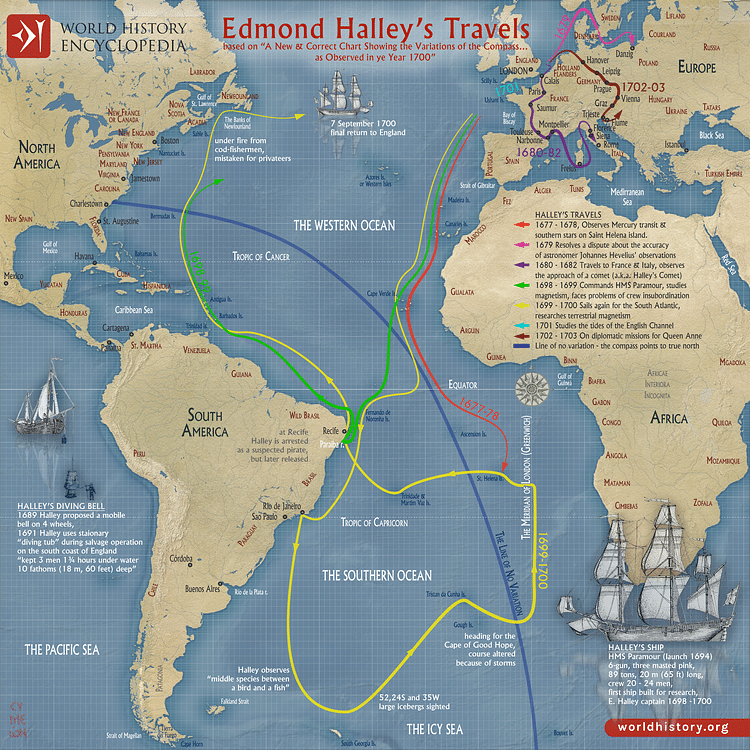
A map illustrating the travels of the English polymath (astronomer, mathematician, geophysicist, and meteorologist, …) Edmond Halley (1656–1742) during the late 17th and early 18th centuries. From his earlier voyage on an East India Company ship to Saint Helena Island, when he charted the stars of the Southern Hemisphere, through his travels across Europe tracking the Great Comet of 1680 (Halley's Comet) and later the captaincy of the purpose-built research vessel HMS Paramour on missions to study Earth’s magnetic phenomena and the tides in the English Channel, these travels contributed greatly to the fields of astronomy, navigation, and terrestrial magnetism, establishing Halley's enduring legacy.
Cite This Work
APA Style
Netchev, S. (2023, November 21). Edmond Halley’s Travels. World History Encyclopedia. Retrieved from https://www.worldhistory.org/image/18164/edmond-halleys-travels/
Chicago Style
Netchev, Simeon. "Edmond Halley’s Travels." World History Encyclopedia. Last modified November 21, 2023. https://www.worldhistory.org/image/18164/edmond-halleys-travels/.
MLA Style
Netchev, Simeon. "Edmond Halley’s Travels." World History Encyclopedia. World History Encyclopedia, 21 Nov 2023. Web. 11 Dec 2023.
